Ground Verdict, battery site screening Screen a site free
Battery site screening · New South Wales

Know if a site is worth chasing before you spend a dollar on it.

Send us a lot and DP or a map pin. In about a day you get a clear verdict on that NSW land for a grid battery: grid, competition, vegetation, heritage, neighbours, approvals and rough costs, all from public NSW and federal government data.

No obligation. Your sites stay confidential: we never share, publish or reuse the locations you send us.
AMBER
Workable only on one ~9 ha padStrong location, crowded grid, mostly endangered woodland
3.2 km
to a 330 kV substation
9 of 192 ha
actually usable
Grid capacityPROBLEM
Native vegetationPROBLEM
Nearby homes and noiseCAUTION
Native titleCLEAR
Flood and contaminationCLEAR
All of NSW, including its busiest battery hubs New EnglandCentral-West OranaSouthern TablelandsHunterWagga WaggaRiverina
The problem

Land that looks perfect on a map often isn't.

Developers usually find the deal-breakers months in, after paying for options, consultants and a grid connection enquiry that can cost around $50,000.

Protected bushEndangered woodland that can't be cleared, or costs a fortune to offset.
A jammed gridOther batteries already queued at the same substation.
NeighboursHomes close enough that noise limits rule out the design.
Someone else's rightsMining licences, land claims or easements over the lot.
How it works

Three steps, about a day.

Think of it as a building inspection, but for land before you turn it into a battery site.

1

Send the site

A lot and DP, an address or a map pin, and the battery size you have in mind.

2

We check it

We pull dozens of government and market datasets for that land and read them together, so nothing gets missed between specialists.

3

You get a verdict

A short, visual report: green, amber or red, the problems that matter, rough costs, and the next calls to make.

Where we fit

Not another project map. A verdict on one piece of land.

Project maps and trackers are great for seeing what's being built and where the lines run. Ground Verdict answers the question that comes next: should you chase this exact lot, and what would stop it?

Project maps and trackers

  • Who is building what, and at what stage
  • Where substations and transmission lines run
  • Aerial imagery and project boundaries
  • A wide view across a region or the country

"What's happening around here?"

Ground Verdict

  • A clear green, amber or red verdict on your specific lot
  • The deal-breakers on that land: protected vegetation and clearing rules, threatened species, heritage, nearby homes and noise, mining titles, native title, flood and bushfire
  • How congested the connection point really is, and who is ahead of you
  • The likely approval pathway and timeline, and rough costs from connection to offsets
  • The next calls to make, in order

"Should we chase this exact site?"

Use both: a map to spot an area, then Ground Verdict to check the lot before spending on options, consultants or a connection enquiry.

What we check

Everything that kills a site, in one place.

Every finding links back to its public source, so your team can verify it.

GridDistance to substations and lines, competing batteries in the queue, congestion history and loss factors.
Land and planningLot boundaries, zoning, planning pathway, land value and road access for heavy loads.
EnvironmentMapped native vegetation, clearing rules, threatened species, koala habitat and offset costs.
Heritage and titleNative title, listed heritage, Aboriginal heritage searches, mining titles and Crown land.
Neighbours and communityHomes nearby, likely noise limits, objections to nearby projects and council benefit schemes.
Hazards, time and moneyBushfire, flood, fire history, approval timelines and rough build and connection costs.
A real example

192 hectares that looked perfect. 9 that worked.

We screened a farm beside a major substation near Wellington, NSW. On a map it was ideal. The report found most of it was mapped endangered woodland, the grid was crowded with two large batteries ahead, and only a small corner could realistically host a battery.

That's the kind of surprise we catch on day one, not month six.

Request the full sample report
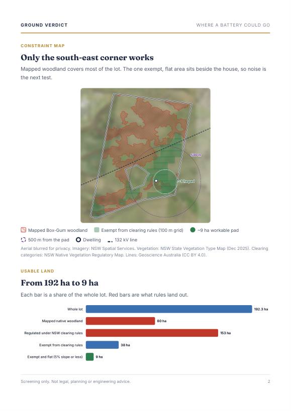
Whole lot192 ha
Regulated under clearing rules153 ha
Mapped endangered woodland80 ha
Exempt from clearing rules38 ha
Exempt and flat enough9 ha
Inside the report

What you actually get.

An 8-page report built for a busy development team: the answer on page one, the evidence behind it, and every source listed.
Report page 1: verdict and key numbers
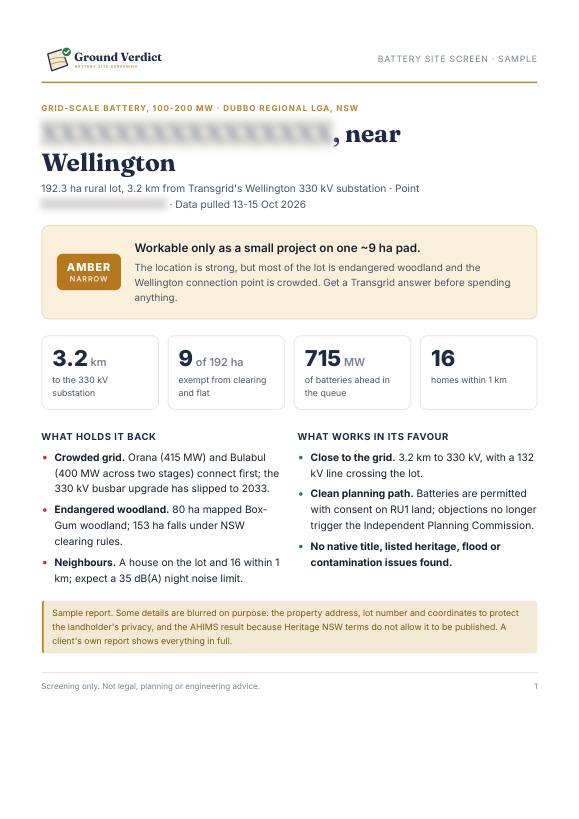
The verdictGreen, amber or red, the key numbers and what holds the site back.
Report page 2: constraint map
Constraint mapWhere a battery could actually go, and how much land is really usable.
Report page 3: scorecard
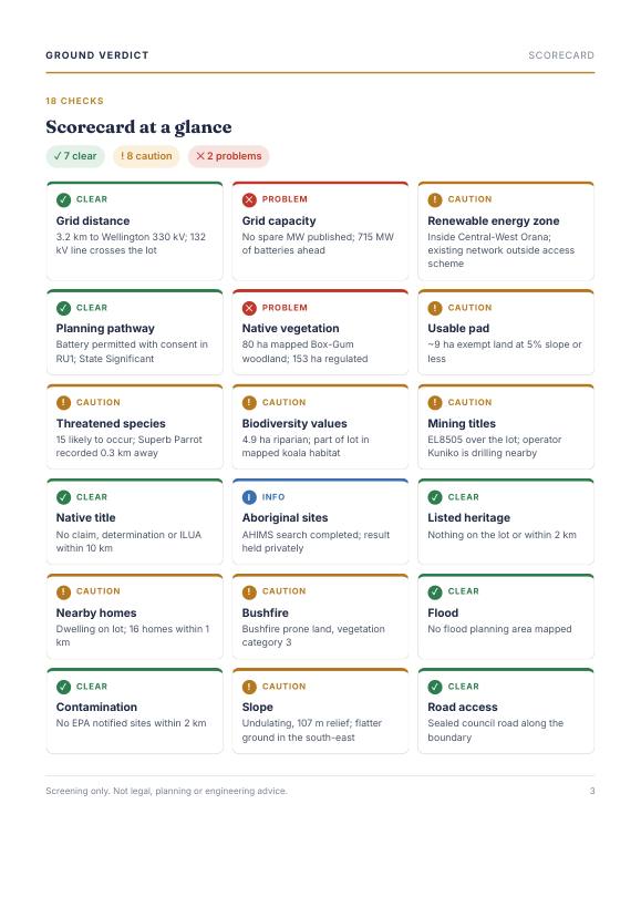
18-check scorecardEvery deal-breaker at a glance, colour-coded.
Report page 6: rough costs and what would turn it green
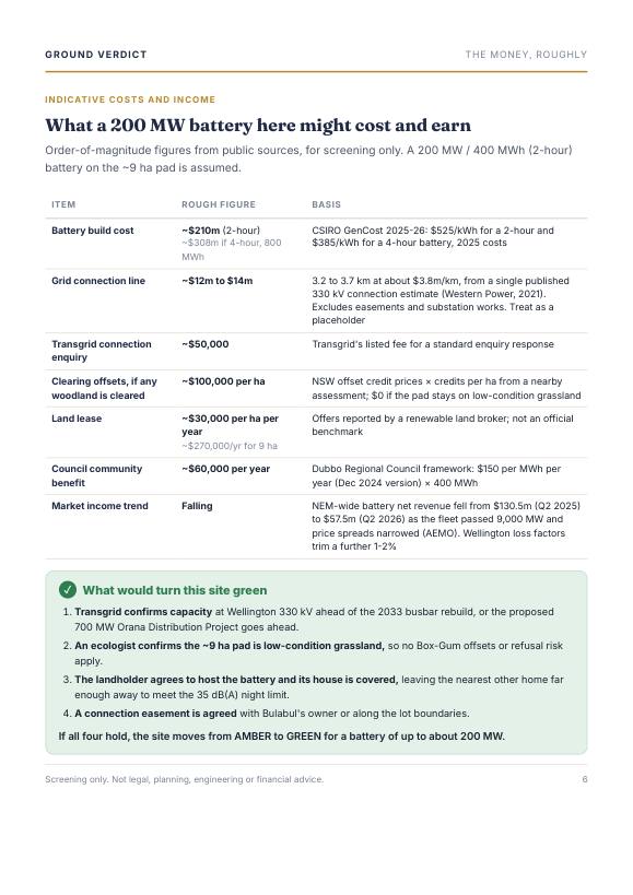
Money and next stepsRough costs, and exactly what would turn the site green.
Get the full sample report

Sample shown with the landholder's details blurred.

Pilot · Limited places

Need sites, not just checks?

We're piloting substation shortlists: we screen every lot near a substation you're targeting and rank the best ones, so your team starts with the strongest land instead of a blank map. Limited places for early partners.

Ask about a shortlist
First site free

Send us a site you're looking at.

Tell us about the site and we'll send your report, then ask for honest feedback in return. Asking for the sample report or a shortlist? Use the same form.

🔒 Your sites stay confidential. We never share, publish or reuse the locations you send us.

Prefer email? Write to [email protected]